Geophysical surveys
ANS Consultants’ geotechnical engineering team has the capabilities of performing non-destructive/non-intrusive geophysical surveys to assist with geotechnical design, project planning and feasibility studies and current construction projects.
ANS Consultants can provide the following geophysical services:
- Ground Penetrating Radar (GPR) Survey
- Electrical Resistivity Tomography (ERT)
- Multichannel Analysis of Surface Waves (MASW)
Ground Penetrating Radar (GPR)
GPR uses radar pulses to image the subsurface. It is most notably used to locate underground obstructions and existing utilities. ANS Consultants uses equipment that can detect metal, plastic, PVC, and concrete as well as detecting lithological changes in the subsurface.
ANS Consultants predominately uses GPR equipment to locate underground utilities and obstructions on a project site prior to conducting geotechnical investigations or excavations during construction phase.
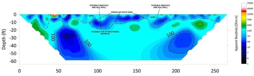
Electrical Resistivity Imaging (ERT)
Electrical Resistivity tests measure the conductivity or inversely, a soil or rocks resistance to electrical current. For grounding studies, a simple 4-point Wenner (ASTM G57 or IEEE 81) test can be run and resistivity values at varying depths can be obtained for grounding design. As different soils and bedrock contain different electrolytic properties, a more complex test, Electrical Resistivity Imaging can be run using 28, 56, 84, or even 112 electrodes spaced evenly along a survey line.
A current is expelled in defined sequences from a resistivity meter to the different probes installed in the ground. Other probes, in sequence, measure a potential drop. These values are comparable to depth within the subsurface at a particular point and provide a resistivity in Ohm-feet or –meters. With many data points collected, an inversion can be made using specialized software and a two-dimensional subsurface image is obtained.
The image can aid in visualizing different soil-rock layers and anomalies along long stretches of land. When it is necessary to determine subsurface conditions within large properties, ERT surveys are very beneficial.
Some benefits of ERT surveys are listed below:
- Sinkhole/void location
- Mapping caves or mines
- Mapping of depth to bedrock
- Groundwater table investigation
- Mapping of bedrock fracture zones
- Contamination plumes
- Landfill delination
- Archaeological investigations
Seismic Testing
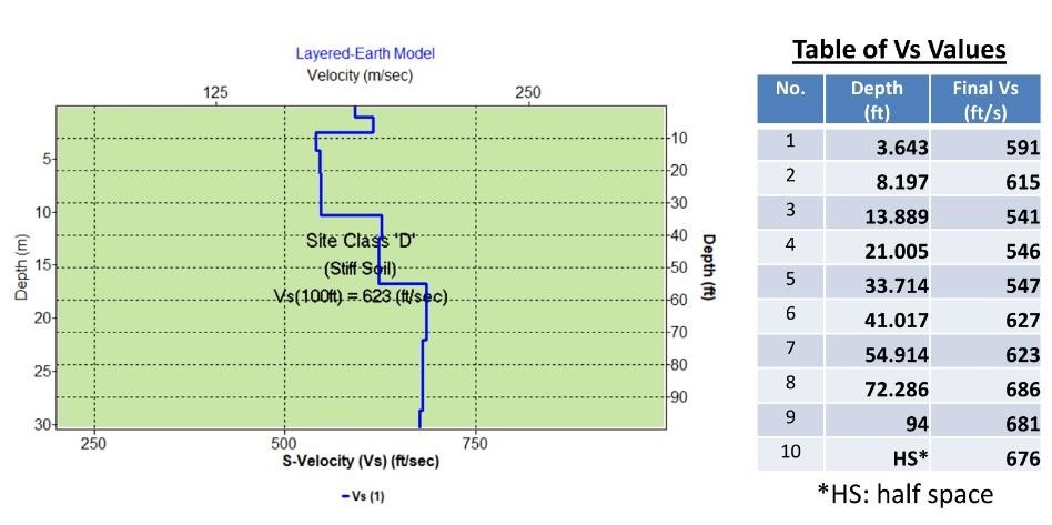
Multichannel Analysis of Surface Waves (MASW), Seismic Refraction
Mutli-Channel Analysis of Surface Waves (MASW) surveys are completed by using a Seismograph and strategically placed geophones to measure particular waves created by an active (ie sledgehammer) or passive (ie urban noise) noise source.
The noise sources produce surface seismic waves, which propagates horizontally along the existing ground surface from the impact point to the geophone receivers. This method converts the surface seismic into shear-wave velocities, which can be used for the following:
- Mapping depth of bedrock or glacial till
- Determine subsurface profiles, layer changes, and stiffness of soils and bedrock
- Seismic Site Characterization
- Assist with Liquefaction analysis
- Compaction evaluations
- Anomaly detection
Seismic Refraction
Seismic refraction maps contrasts in seismic velocity – the speed at which seismic energy travels through soil and rock. This parameter typically correlates well with rock hardness and density, which in turn tend to correlate with changes in lithology, degree of fracturing, water content, and weathering.
- Map depth of bedrock or glacial till
- Map lithology of subsurface
- Estimate rippability of shallow bedrock
- Calculate elastic moduli of soil and rock